|
The
landscape of Baker County has been shaped by many geologic processes. Many
of the older rocks that form the cores of the Wallowa and Elkhorn
Mountains are exotic; fragments of islands and oceans that were formed
several hundred million years ago in the ancestral South Pacific.
The fragments, which are now called terranes, were
transported by the process of plate tectonics to the land we now know as
Baker County, which marked the westernmost boundary of the American
continent some 200 million years ago. The rocks in Baker County of that
age were parts of the ancestral Pacific Ocean that were scraped off
against the continental margin which lay in western Idaho. Fragments of
the old island chains can be seen today in Hell's Canyon and in the
Wallowa Mountains. Fragments of the old ocean floor can be seen in the
bold peaks of Elkhorn Ridge.
The character of the land began to change about 160
million years ago as the old ocean floor became welded or accreted to the
continent with the ocean shores shifting to central Oregon. Masses of
molten rock rose up along fractures within the accreted terranes and
cooled, becoming the granitic rocks that now make up the cores of the
Wallowa and Elkhorn Mountains. The batholiths, (melted igneous rock
intruded into other stratas), would be important to the future settlement
of Baker County, for they were the heat engines that drove the
hydrothermal systems that filled many of the old fractures with
gold and silver.
Baker County lay' above the seas for the next 100
million years. The gold veins were exposed by wind and water as the land
rose and the rocks were stripped away by erosion. The only evidence from
this time is found in the fragments of the fossil tree-fern, Tempskya,
that is scattered through the old placer gravels at Greenhorn. (See
rare specimens at Oregon Trail Regional Museum, (J. R. E.).
Violent changes racked the landscape, starting about 40
million years ago. Volcanoes rose above the countryside and lava flows
blocked and buried the old stream channels, forming the buried placer
deposits that were later mined at Parkerville and Winterville. Some of the
volcanic centers generated their own hydrothermal systems, forming new and
different types of mineral deposits. Remnants of these old volcanoes can
still be seen in the Greenhorn area.
The nature of the volcanic eruptions changed about 15
million years ago. Massive outpourings of basalt rose up along fissures
near the old continental margin along Snake River. The basalts flowed out
across the landscape in vast sheets that covered hundreds of square miles,
in some cases flowing down the ancestral Columbia River to the sea west of
Portland. Some of the feeders to the flows can be seen today above
Cornucopia in the Wallowa Mountains. The basalts are known today as the
Columbia River Basalts and constitute one of the largest outpourings of
these types of lavas in the world.
For reasons not yet fully understood, the basalts
covered only parts of the northern half of Baker County. South of Baker
City, the lavas were more explosive rhyolites which emanated from vent
areas like Dooley Mountain. (See
note #1).
The eruptions were more explosive, generating vast
clouds of volcanic ash that poured out over the countryside to the south.
In many ways, the area from Dooley Mountain south to Burns and Ontario was
similar to the present-day Yellowstone Park area, with fields of hot
springs and mounds of rhyolitic magmas.
As the lavas cooled, the earth's surface began to
buckle and break. The rocks were folded and faulted, resulting in the
formation of the present-day Baker, Sumpter, and Eagle Valleys, which were
later cut through by the Powder and Burnt Rivers as the landscape
continued to buckle. (See also
notes #2 and
#3).
The latest agent to shape the land was the ice from the
mountain glaciers that formed during the Ice Ages. The glaciers did not
reach the valley floors, but water from their melting spread deposits of
boulders and gravels across parts of the Sumpter, Eagle, and Baker
Valleys. Small sporadic earthquakes attest to continuing buckling and
breaking of the earth's crust beneath the valleys while the hot springs
provide evidence of the heated rocks below. (MARK FERN, Geologist,
Regional Office of Dept. of Geology and Mineral Industries, Baker,
Oregon).
Geology: Some Applications
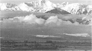
In modern Baker County, that
geology translates into a varied geography, which, in turn, means a
dramatic range in elevations from 1,600 to 10,000 feet, and a consequent
range of climate. The earth's contortions have produced many valleys, with
many land forms, various natural water systems, and varying industry and
agriculture, all of which affect social and business structure and
transportation systems.
Based on the geologic upthrusts, mountains dominate
Baker County. Four streams of significance to Eastern Oregon rise in the
mountain mass where the Greenhorn and Blue Mountains dominate the
Wilderness. The John Day River heads generally westward for the Columbia;
the Grande Ronde north to the lower Snake; the Powder and Burnt Rivers
east to the Snake River above Hell's Canyon.
The Burnt River and the Powder River are the major
drainages of the county. In its 75 miles, the Burnt River flows from the
6,000 foot plus level through Whitney and Unity basins at 4,000 feet, the
three branches join and cut through the mountain range at Burnt River
Canyon to Durkee and the river takes a tumultuous course to the Snake
River at Farewell Bend at about 2,200 feet.
Rising in the gold country above Sumpter, Powder River
flows through Sumpter Valley at about 4,400 feet to swing around the
Elkhorn Range to Baker Valley at about 3500 feet to join the North Powder
River and to swing again east to Keating and Eagle Valleys and to join the
Snake at Richland at about 2,100 feet.
Eagle creek is significant to Eagle Valley, and Pine
Creek to Pine Valley, each plunging from the Eagle-Wallowa range and
entering Snake River above Hell's Canyon.
Thus, Baker C aunty has a climate ranging roughly from
the 9,000 foot to the 2,000 foot level in its I 1 distinct valleys. The
climate might be classified as modified Continental, with generally clear
skies and somewhat severe winters.
Winter temperatures average 26 degrees in January with
extremes to sub-zero. Summers are moderately warm with a July average of
67 degrees and rarely to 100 degrees. Annual precipitation is about 11.25
inches, with abundant snow in mountain areas.
The growing season is limited by varying elevations.
Higher valleys are limited to about 90 frost-free days. Valleys are
devoted principally to raising cattle, grain and hay.
The Wallowa, Blue, and Malheur Mountains, which rim the
county, and the Elkhorn and Lookout Ranges contain about one half of
Oregon's peaks above 7,000 feet. The highlands and wilderness areas are
popular for skiing, hiking, horse-packing, fishing, and big game hunting
in season, and snowmobiling in designated areas.
Trails are numerous and major access roads include the
Elkhorn Loop, Highway 7 and Highway 26 to John Day, Highway 86 to Hell's
Canyon and Wallowa, the Snake River Road from Farewell Bend to Richland,
Eagle Creek Drive, Highway 203 to Pondosa, and several back-country roads.
Some of the parks available are at Farewell Bend,
Anthony Lakes, Oxbow, Unity, Hell's Canyon, Richland, Phillips Reservoir,
and there are others.
National recreation areas include Eagle Creek and
Hell's Canyon Wilderness Areas, and the Hell's Canyon Recreation Area.
The Transcontinental Highway 84, the Union Pacific
Railroad, oil and gas lines, and transcontinental communication use the
traditional Oregon Trail route across the county.
Native American, Prehistory and History
Baker County was the homeland of
Native American people for nearly ten thousand years before the arrival of
fur traders, explorers, missionaries and settlers. Native American groups
which inhabited Baker County came to be known in later years as the
Cayuse, Umatilla, Walla Walla, and Nez Perce peoples of the southern
Plateau, and the Paiute peoples of the northern Great Basin.
Hunting and fishing areas were shared among the Plateau
people, although traditional band and village occupation areas were
recognized. The evidence of their occupation has been found in prehistoric
hunting and plant gathering camps, rockshelters, riverside villages, and
rock art in Baker County. The numerous archaeological sites and
prehistoric artifacts on federal lands in Baker County are protected by
law, to preserve evidence of this unique and enduring Native American
cultural heritage for education and future scientific study.
In the thousands of years before the eruption of Mt.
Mazamam (6,700 years ago at Crater Lake), the native people of Baker
County hunted large game animals using spears. Evidence from
archaeological sites in the region shows that among the animals hunted
were elk, deer, pronghorn antelope, native bison, and rabbits. The people
fished and gathered river mussels and plant foods. They traveled about the
county in small groups, using the resources of the lakes, streams, rivers,
and upland mountains.
After the eruption of Mt. Mazama, people adopted the
widespread use of a new hunting technology, the short spear or dart thrown
from a hooked cradle device called an atlati, or speart-thrower. The
presence of ground milling stones in archaeological. sites indicates that
the people were also gathering and processing. plant seeds and vegetables
for food. Many of the stone tools, including spear or dart points, knives,
and scrapers were manufactured of a fine-grained volcanic basalt found
locally.
Between about 5000 and 2000 years ago, the people
began to use stone pestles and hopper mortars to crush the roots of
several important plant foods found in this area. Some of these plants are
biscuitroot, camas, wild carrot, bitterroot, spring beauty, and yellow
bell. Berries were also gathered from the mountains, the most important of
which were serviceberry and huckleberry. Evidence of net-making and net
sinkers appears in the archaeological record, a firm indication of
fishing. River mussels continued to be gathered b the people. Later,
hunters adopted the use of y the bow and arrow to pursue their
game. Some of these people began to live in pithouses along the major
lower elevation rivers such as the Snake.
Between the period 2000-200 years ago the lifeway of
the people become progressively oriented toward a seasonal scheduling of
resource use between the river valleys and mountains. Gathering along the
Snake River near its major tributaries, Plateau people lived in the small
village groups of pithouses during the winter. Various structures in
winter villages included pole and reed mat lodges and the sweat house.
Some longhouse lodges housed many families and are known to have reached
lengths of 100 feet. During the winter the people subsisted on fish,
occasional game, and the preserved foods they had prepared during the
previous seasons. Food was cooked in watertight baskets using boiling
stones. Mountain sheep were hunted in the Snake River canyon during the
winter months. Winter was a time for maintenance of tools and articles,
for dance ceremonies, telling stories and teaching the youth. The . people
believed that assistance and power could be acquired from the spirits
present in animate creatures, inanimate objects and forces of nature.
Young boys and girls. often went to remote localities to seek
their guardian spirit by undergoing an arduous vigil of fasting.
Historian note
1: (indexed to Geology text
above.) Many of Baker's historic buildings are constructed of grey
volcanic tuff quarried from the deposits mentioned. More recently,
colorful "Moon Mesa" stone, also of volcanic origin and appearing on
Dooley Mountain, has been used as a surface for several buildings. (J.R.E.)
Historian note
2. (Indexed above): Although not
unanimous, some geologists hold that all of the valley lands of Southern
Idaho and of Baker and Malheur counties were once under the enormous
Payette Lake, which overflowed through Baker Valley and into the Grande
Ronde and thus to the lower Snake River.
The present course of Snake River through Hell's Canyon
developed as water from the lake followed broad faults and began to cut
through along the fracture lines resulting from the crushing as the fault
edges moved against each other. (J.R.E.)
Historian note
3: (Indexed above): The Powder
and Burnt Rivers eroded the passageway used by the Oregon Trail and now
modern transportation through Baker County.
Hell's Canyon is the only drainage of Baker and Malheur
counties and of Southern Idaho. For more information, see also Dr. John
Allen's Time Travel in Oregon, Howard Brooks' "Plate Tectonics and
the Geologic History of the Blue Mountains," Oregon Geology, May
1979; Ewart M. Baldwin, Geology of Oregon, Third Edition: and
articles listed in Oregon Geology. (J.R.E.)
Index
| Next |